
The heat wave in Switzerland is still going on, and the best way to escape it is to go up to the mountains and higher lakes. This hike is going up to the Waldisee: a lake high at the end of the Bisistal, Canton Schwyz, Switzerland.
Waldisee
The Waldisee is a small lake at 1404 meter. The lake is used for electricity production and nearby there is a beautiful waterfall feeding the lower Salisee
The map below shows our hike counter-clockwise: starting at 1088 meter, going up the Schlänggen and the Rinderplang, reaching the Hütten and Steinhütten and then passing by the Waldisee. Descending down the Spitzäch creek and then up again to the Milchbüelen (1359 m), going through the Eigeli and reaching Feldmoos, then descending the Schmallauiblätz down to the Sali Lake and finally returning to our starting point:

Waldisee Wanderung
From the starting point it goes up on the trail, with the Waldistöck high above us:

Waldistöck

Alp Stäflen
We were able to watch multiple marmots while going higher and higher.

View to Bärenloch
Reaching Rinderplangg:

Hütten

Rinderplangg
Road to the Steinhütte:

Hüttenweg
Approaching Hütten:

Reaching Steinhütte

Hütte

Steinhütte
View back to Steinhütte:

View back to Steinhütte
Cross at Alpwirtschaft Waldi Alp:

Cross at Waldi Alp
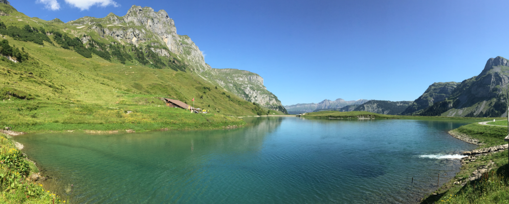
Then we reached the West end of Waldisee:

Waldisee

Waldisee (click to enlarge)

Bänkli

Waldisee

Waldisee (clickto enlarge)
Heading down to the Bisistal again:

Ruosalper Bach

Butterfly

Gwalpetenbach
At the sign post, taking the trail up to the Glattalp and Milchbüelen:

Signpost to Glattalp
View down to the Salisee:

Salisee

Road to Milchbüelen

Waldisee Fall
Milchbüelen with the cable car we took on our previous hike (“Hiking the Grossbodenkreuz and around the Glattalpsee“).

Milchbüelen

Flora and Fauna

Hiking Trail
View over to the Waldisee where we came from:

Waldisee Fall

Butterfly
Approaching Feldmoos:

Feldmoos

Feldmoos

Signpost at Feldmoos
After Feldmoos, we took the trail down to Schmalaui. That trail goes down on Alpine meadow:

Schmalaui

Distel

Peppermint
View to the other side and Rinderplangg which was our first ascend on this tour:

Rinderblangg (click to enlarge)
A road takes as down to the valley and Salisee:

Road to Salisee

Salisee

Salisee
From here it was a short walk back to our starting point.
I hope this is an inspiration for you to explore that beautiful area.
Happy Hiking 🙂
Links
- Salisee: https://www.schweizersee.ch/salisee/
- Waldisee: https://www.schweizersee.ch/waldisee/
- Waldiranch: https://www.facebook.com/waldiranch

Beautiful.
LikeLike